Garmin GPSMAP 9027 Premium chartplotter with worldwide base map
SKU:010-02676-00
- Regular price
- £12,995.95 inc. VAT
- Sale price
- £12,995.95
- Regular price inc. VAT
-
£15,520.00
Flexible Shipping Options - inc. Next Working Day UK Mainland
Click & Collect - available at Morgan Marine, Brightlingsea.
30-Days Free Returns - see our returns policy
Rated - 4.6 / 5 on Google ⭐⭐⭐⭐⭐
Trusted - Marine supplier since 1972
Fast - UK delivery
Garmin GPSMAP 9027 Premium chartplotter with worldwide base map
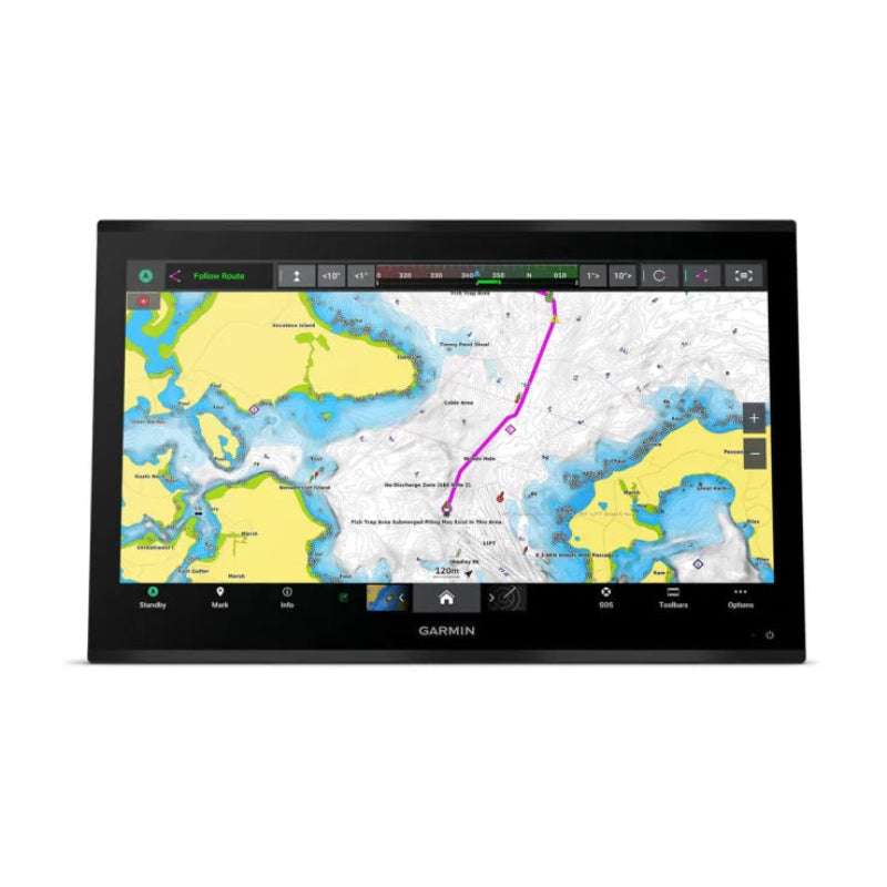
Garmin GPSMAP 9027 Premium chartplotter with worldwide base map are a premium 27-inch integrated 4K touchscreen chartplotter that offers a luxurious glass helm design, exceptional processing power, and extensive networking capabilities for marine navigation and fishing. It comes with a worldwide basemap and is built for demanding captains and anglers.
Garmin GPSMAP 9027 Premium chartplotter with worldwide base map Key Features
- Display Quality: Features a premium 4K IPS sunlight-readable touchscreen display with an edge-to-edge glass design, offering a modern, sleek look and visibility from any angle.
- Performance: Equipped with a processor that is up to 7 times faster than previous generations, allowing for rapid chart drawing and quick calculation of routes.
- Networking Speeds: Utilizes the gigabit Garmin BlueNet™ network for 10 times faster networking speeds, ensuring minimal lag when building extensive systems with multiple chartplotters, cameras, radars, and sonars.
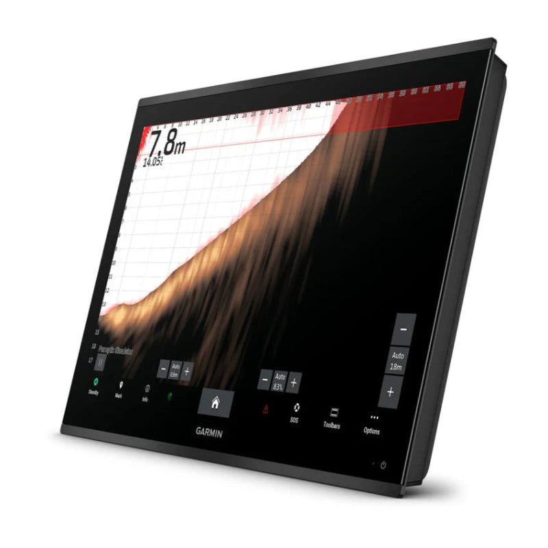
- Sonar Integration: Supports a wide range of compatible black box sonar modules (sold separately) including Traditional, ClearVü, SideVü, Panoptix™, and LiveScope™ systems, with the ability to view targets in high definition on the 4K screen.
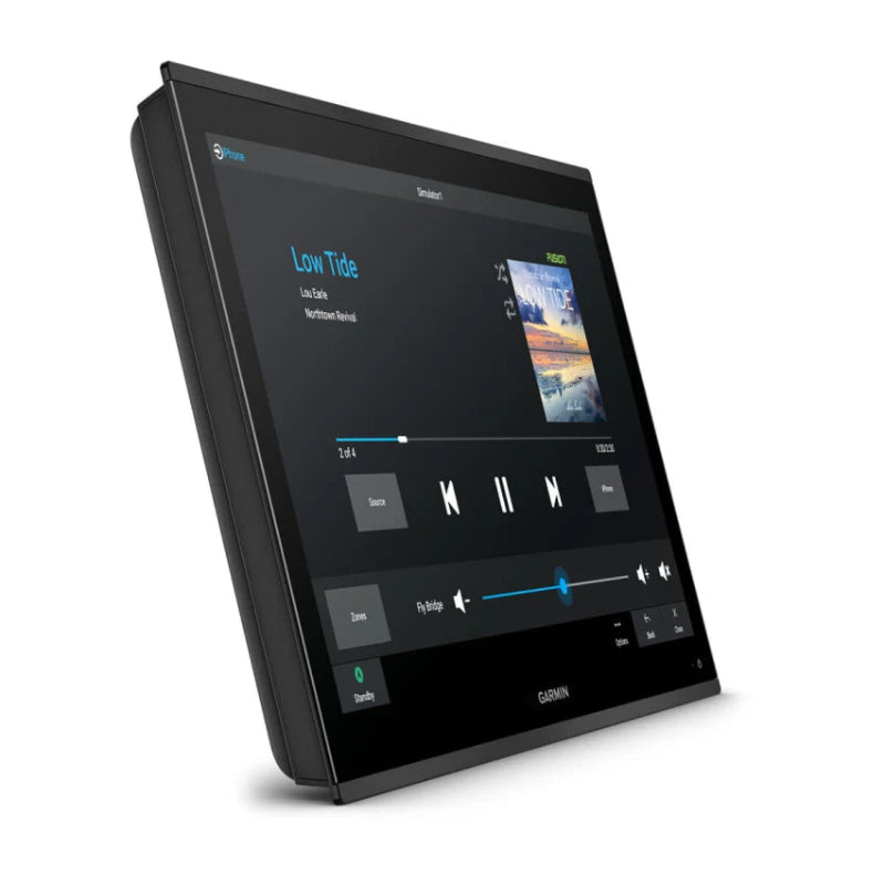
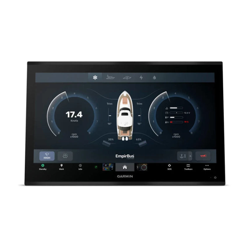
- Comprehensive Integration: Allows for command and control of the entire vessel ecosystem through various integrations, including NMEA 2000® and NMEA 0183 networks, OneHelm™ digital switching, engine monitoring, and the Garmin Surround View Camera System (accessories required).
- Mapping & Navigation: Comes with a worldwide basemap and supports optional premium charts like Garmin Navionics+™ and Garmin Navionics Vision+™ with features like Auto Guidance+™ technology, daily updates, and high-resolution relief shading (subscriptions required).
- Wireless Connectivity: Offers integrated Wi-Fi®, Bluetooth®, and ANT® technologies for seamless connectivity with compatible devices, including smartphones via the ActiveCaptain® app and Garmin smartwatches for remote control.
- Durability: Built for harsh marine conditions with an IPX7 water-resistance rating.
- Control Options: Can be controlled via the touchscreen, a compatible headset for verbal commands, or a compatible wireless remote control like the GRID™ 20 remote input device.
Garmin GPSMAP 9027 Premium chartplotter with worldwide base map FAQs
- What is the display resolution? The Garmin GPSMAP 9027 features a high-definition 4K IPS (In-Plane Switching) touchscreen display with a resolution of 3840 x 2160 pixels.
- Does it have built-in sonar? The unit has Garmin's best built-in sonar capabilities, including 1 kW xCHIRP, Garmin RapidReturn™ sonar, and UHD scanning sonar. However, transducers and a compatible sonar black box are typically sold separately to enable these features.
- What kind of network connectivity does it offer? It offers extensive connectivity via the Garmin BlueNet™ network for up to 10 times faster speeds, as well as NMEA 2000® and NMEA 0183® networks. It also has Wi-Fi®, Bluetooth®, and ANT® connectivity.
- Does it support digital switching? Yes, it supports the EmpirBus™ system and other third-party solutions via OneHelm™ integrated digital switching for monitoring and controlling various vessel systems.
- What is included with the "worldwide base map"? The included worldwide base map provides basic, non-detailed maps for general reference. For detailed navigation, the device works with optional charts like Garmin Navionics+™ or Garmin Navionics Vision+™, which require a separate purchase or subscription.
- Does it have Auto Guidance+? Yes, the chartplotter supports Auto Guidance+™ technology, which can calculate routes quickly; however, this feature is available with an optional Garmin Navionics+ or Navionics Vision+ subscription and is for planning purposes only, not a replacement for safe navigation operations.
- How do I update the charts and software? Software updates can be managed through the Garmin ActiveCaptain® app on a compatible smartphone or tablet. You can also use the Garmin Express program on a computer.
- Can I share charts between multiple chartplotters? Yes, chartplotters connected on the same network can share built-in maps and data from pre-programmed chart car