Garmin GPSMAP 9024 Premium chartplotter with worldwide base map
SKU:010-02675-00
- Regular price
- £11,395.00 inc. VAT
- Sale price
- £11,395.00
- Regular price inc. VAT
-
£13,619.99
FREE UK shipping on orders over £150. Exclusions apply.
Shipping calculated at checkout.
Click & Collect - available at Morgan Marine, Brightlingsea.
30-days Free Returns - see our returns policy
Rated - 4.6 / 5 on Google ⭐⭐⭐⭐⭐
Trusted - Marine supplier since 1972
Fast - UK delivery
Garmin GPSMAP 9024 Premium chartplotter with worldwide base map
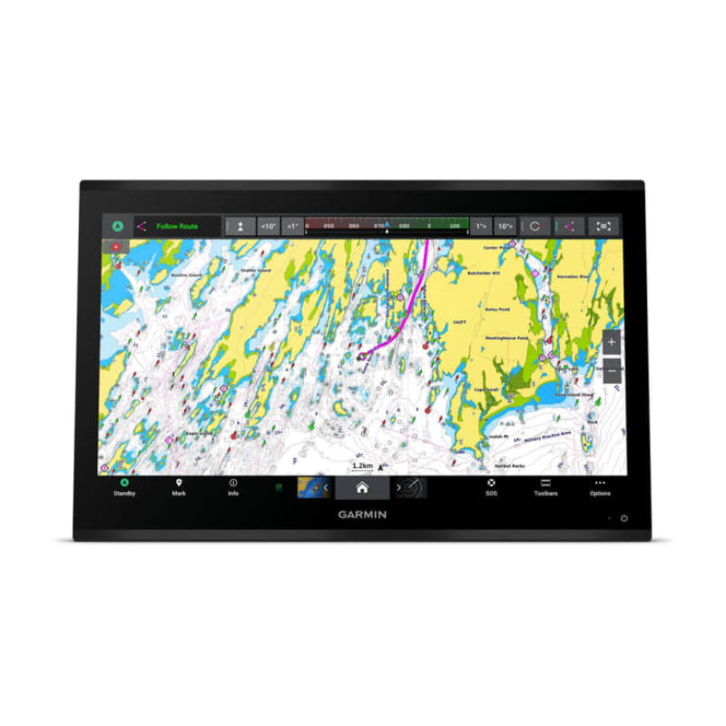
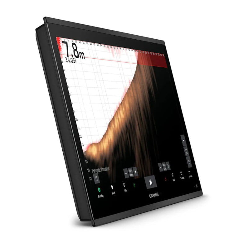
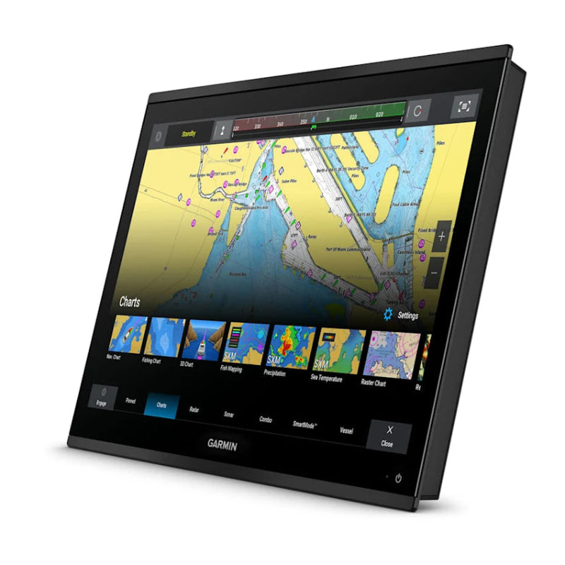
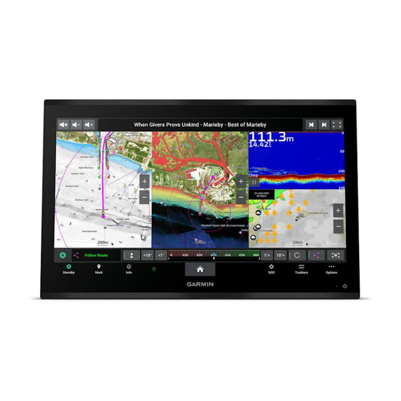
Garmin GPSMAP 9024 Premium chartplotter with worldwide base map are a premium 24-inch integrated 4K resolution touchscreen chartplotter that offers high-performance processing, extensive network capabilities via the Garmin BlueNet network, and a worldwide basemap. It is designed for luxury "glass helm" installations and comprehensive vessel integration.
Garmin GPSMAP 9024 Premium chartplotter with worldwide base map Key Features
- Display: Features a premium 24-inch 4K IPS sunlight-readable touchscreen display with an edge-to-edge glass design, offering exceptional clarity for navigation, sonar, and video.
- Performance: The chartplotter has processing power that is up to 7 times faster than previous generations, allowing for rapid chart drawing and quick calculation of routes (with a subscription to optional Garmin Navionics+ charts).
- Networking & Integration: It utilizes the Garmin BlueNet network, which provides gigabit speeds (10 times faster than previous networks) for seamless integration with multiple chartplotters, cameras, radars, and sonar modules. It also supports NMEA 2000® and NMEA 0183 networks for a wide range of accessories and systems, including engine monitoring and autopilot control.
- Sonar Capabilities: The device can display high-definition sonar when connected to compatible Garmin black box sonar modules (transducers are sold separately). It is compatible with a full range of systems, including Panoptix™ and LiveScope™ sonar.
- Mapping & Navigation: It comes with a preloaded worldwide basemap. Users can enhance navigation with optional charts like Garmin Navionics+ and Garmin Navionics Vision+, which offer features such as Auto Guidance+ technology and high-resolution relief shading (subscriptions required).
- Connectivity: Includes integrated Wi-Fi® and BLUETOOTH® wireless technologies, allowing for software updates via the ActiveCaptain® app and connection to other devices like compatible Garmin smartwatches or headsets for verbal commands.
- Durability: Built to withstand harsh marine conditions with an IPX7 water-resistance rating.
| Dimensions | 22.7″ x 14.8″ x 2.7″ (57.6 cm x 37.6 cm x 6.9 cm) |
| Weight | 20.60 lbs (9.34 kg) |
| Display Resolution | 3840 x 2160 pixels |
| Mounting Options | Flush or flat |
| Water Rating | IPX7 |
Garmin GPSMAP 9024 Premium chartplotter with worldwide base map FAQs
- Does the GPSMAP 9024 have a built-in GPS receiver? No, the chartplotter does not have a built-in GNSS (GPS) receiver. It includes an external GPS 24xd NMEA 2000® receiver and an NMEA 2000 starter kit in the box.
- Is a sonar transducer included? No, the chartplotter is a non-sonar model. It can display sonar targets, but a compatible sonar black box module (e.g., GSD, GCV) and transducers must be purchased separately and connected to the unit.
- How do I update the software and maps? You can update the device software and maps by connecting the chartplotter to a Wi-Fi network and using the ActiveCaptain app on your compatible smartphone or tablet. You can also download updates via Garmin Express software and an SD card.
- Can I connect my smartphone or tablet to the device? Yes, the device features wireless connectivity via BLUETOOTH® and ANT® technologies, and is compatible with the free all-in-one ActiveCaptain app for features like software updates, map management, and remote notifications .