Garmin GPSMAP 9019 Premium chartplotter with worldwide base map
SKU:010-02673-00
- Regular price
- £7,599.95 inc. VAT
- Sale price
- £7,599.95
- Regular price inc. VAT
-
£9,049.99
FREE UK shipping on orders over £150. Exclusions apply.
Shipping calculated at checkout.
Click & Collect - available at Morgan Marine, Brightlingsea.
30-days Free Returns - see our returns policy
Rated - 4.6 / 5 on Google ⭐⭐⭐⭐⭐
Trusted - Marine supplier since 1972
Fast - UK delivery
Garmin GPSMAP 9019 Premium chartplotter with worldwide base map
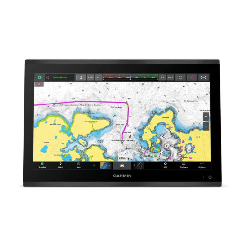
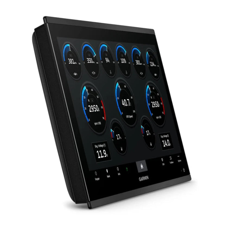
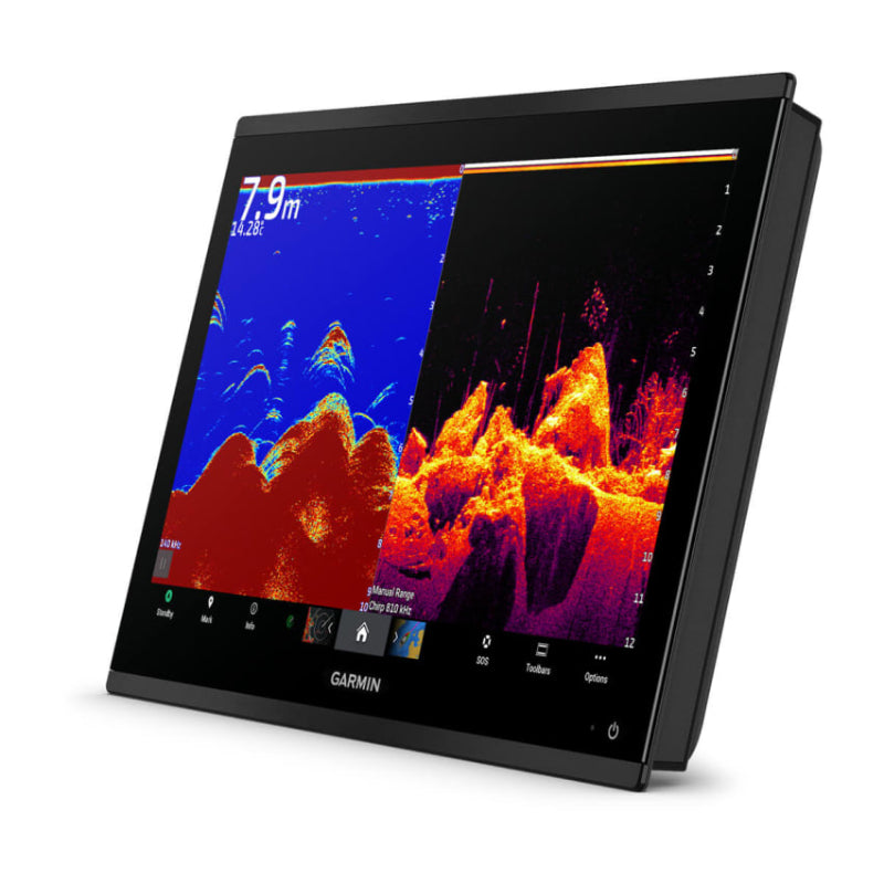
Garmin GPSMAP 9019 Premium chartplotter with worldwide base map are a premium 19-inch 4K touchscreen chartplotter that serves as an integrated command centre for vessels, featuring a worldwide base map, advanced networking capabilities, and high-speed processing power. It offers a seamless, edge-to-edge glass helm design for a modern look.
Garmin GPSMAP 9019 Premium chart plotter with worldwide base map Key Features
- Display: Features a 19-inch, 4K IPS (In-Plane Switching) sunlight-readable touchscreen display with a high resolution of 3840 x 2160 pixels, providing exceptional clarity and an edge-to-edge design.
- Performance: The unit boasts processing power up to seven times faster than previous generations, which ensures rapid chart drawing, quick route calculations with Auto Guidance+ (optional subscription required), and smooth performance.
- Networking: It utilizes the new gigabit Garmin BlueNet network, offering 10 times faster networking speeds for seamless integration of multiple chartplotters, sonars, radars, and cameras with minimal lag.
- Sonar Support: The chartplotter can display high-definition sonar targets in 4K resolution when connected to compatible black box sonar modules (transducers are sold separately) such as traditional, ClearVü, SideVü, Panoptix, and LiveScope systems.
-
Connectivity and Integration:
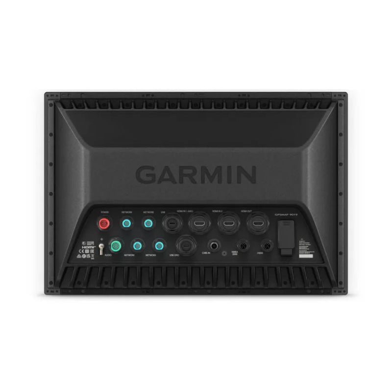
- Networks: Connects to the marine ecosystem via NMEA 2000® and NMEA 0183 networks.
- Wireless: Features integrated BLUETOOTH® and ANT® technologies for connecting compatible smartphones, tablets (via the ActiveCaptain app), and smartwatches, and also supports spoken audio alerts through compatible headsets.
- Video: Offers extensive audio and video integration with HDCP distribution, allowing video to be shown and heard across multiple screens and speakers on the network.
- OneHelm: Provides support for the OneHelm™ integrated digital switching system for monitoring and controlling various on-vessel systems.
- Navigation & Mapping: Comes with a preloaded worldwide basemap, and is compatible with optional premium charts like Garmin Navionics+™ and Garmin Navionics Vision+™ for advanced features such as high-resolution relief shading and satellite imagery.
- Included Hardware: The package includes the chartplotter unit, a power cable, flush mount hardware, trim snap covers, and a GPS 24xd NMEA 2000® position receiver and antenna kit.
- Durability: It is built for harsh marine environments with an IPX7 water-resistance rating.
Garmin GPSMAP 9019 Premium chartplotter with worldwide base map FAQs
- What is the display resolution? The Garmin GPSMAP 9019 features a 4K (3840 x 2160 pixels) IPS sunlight-readable touchscreen display.
- What are its physical dimensions? According to multiple retailers, the dimensions are 18.0" x 12.0" x 2.7" (45.7 cm x 30.5 cm x 6.9 cm).
- Is it waterproof? Yes, it has an IPX7 water-resistance rating, meaning it is built for harsh marine conditions.
- What comes in the box? The box typically includes the GPSMAP 9019 chartplotter, a protective cover, flush mount hardware, a power cable, a GPS 24xd NMEA 2000 antenna (with various mount adapters), NMEA 2000 cables and connectors, and documentation.
- Does the "worldwide basemap" include detailed charts? The worldwide basemap provides basic, non-detailed maps for general reference. For detailed navigation and advanced features like Auto Guidance+ technology and daily updates, you must purchase an optional subscription to Garmin Navionics+ or upgrade to Garmin Navionics Vision+ charts.
- What premium chart features are available with an optional subscription?Optional premium charts (Garmin Navionics Vision+) can include high-resolution relief shading, high-resolution satellite imagery, 3D views (above and behind the boat and underwater), and detailed aerial photos of marinas and landmarks.
- How do I get map updates? Map updates are available via a subscription and can be downloaded using the free ActiveCaptain app on a compatible smartphone or tablet.
- Can I connect it to other devices? Yes, the chartplotter supports an extensive ecosystem through various networking options, including the Garmin BlueNet network (which offers gigabit speeds), NMEA 2000®, and NMEA 0183 networks. This allows integration with multiple chartplotters, cameras, radar, sonar, and more.
- Does it support sonar? The base unit displays sonar data, but the sonar black box and transducers are sold separately. It is compatible with various Garmin sonar modules, including Panoptix and LiveScope.
- Can I control the system remotely? Yes, you can use the ActiveCaptain app for monitoring and control. You can also connect a compatible Garmin smartwatch to control the chartplotter or use spoken commands with a compatible headset.